


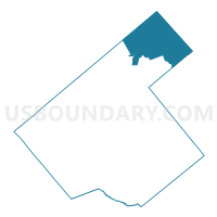
Voting District 0003, Karnes County, Texas
About
Outline

Summary
| Unique Area Identifier | 675192 |
| Name | Voting District 0003 |
| County | Karnes County |
| State | Texas |
| Area (square miles) | 76.76 |
| Land Area (square miles) | 75.97 |
| Water Area (square miles) | 0.79 |
| % of Land Area | 98.98 |
| % of Water Area | 1.02 |
| Latitude of the Internal Point | 29.13412950 |
| Longtitude of the Internal Point | -97.73069050 |
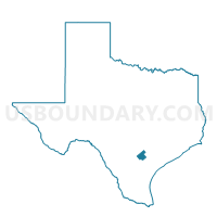
Maps

Graphs
Select a template below for downloading or customizing gragh for Voting District 0003, Karnes County, Texas


Neighbors
Neighoring Voting District (by Name) Neighboring Voting District on the Map
- Voting District 0006, Karnes County, TX
- Voting District 0007, DeWitt County, TX
- Voting District 0008, Karnes County, TX
- Voting District 0010, Gonzales County, TX
- Voting District 0209, Wilson County, TX
- Voting District 0419, Wilson County, TX
- Voting District 0424, Wilson County, TX
Top 10 Neighboring County Subdivision (by Population) Neighboring County Subdivision on the Map
- Yorktown CCD, DeWitt County, TX (4,107)
- Stockdale CCD, Wilson County, TX (3,954)
- Smiley CCD, Gonzales County, TX (1,069)
- Gillett CCD, Karnes County, TX (724)
Top 10 Neighboring Unified School District (by Population) Neighboring Unified School District on the Map
- Nixon-Smiley Consolidated Independent School District, TX (4,957)
- Karnes City Independent School District, TX (4,642)
- Stockdale Independent School District, TX (4,325)
- Poth Independent School District, TX (3,754)
- Yorktown Independent School District, TX (3,510)
- Falls City Independent School District, TX (1,745)
Top 10 Neighboring State Legislative District Lower Chamber (by Population) Neighboring State Legislative District Lower Chamber on the Map
- State House District 44, TX (194,258)
- State House District 35, TX (151,882)
- State House District 30, TX (147,611)
Top 10 Neighboring State Legislative District Upper Chamber (by Population) Neighboring State Legislative District Upper Chamber on the Map
Top 10 Neighboring 111th Congressional District (by Population) Neighboring 111th Congressional District on the Map
- Congressional District 28, TX (851,824)
- Congressional District 25, TX (814,381)
- Congressional District 15, TX (787,124)
Top 10 Neighboring Census Tract (by Population) Neighboring Census Tract on the Map
- Census Tract 5, Wilson County, TX (3,954)
- Census Tract 9705, DeWitt County, TX (2,708)
- Census Tract 6, Gonzales County, TX (2,515)
- Census Tract 9701, Karnes County, TX (2,214)
Top 10 Neighboring 5-Digit ZIP Code Tabulation Area (by Population) Neighboring 5-Digit ZIP Code Tabulation Area on the Map
- 78160, TX (4,273)
- 78118, TX (3,976)
- 78164, TX (3,796)
- 78140, TX (3,380)
- 78159, TX (1,023)
- 78116, TX (390)